

Our professional and experienced skippers have sailed in all possible routings of Greek seas and islands under all circumstances, and are well aware of weather conditions throughout all seasons. Having in mind all the above factors they have planned routings that can be realized within 3 and 4 days. The routings are designed based on your own pleasure and comfort. We chose destinations that can meet even the most demanding character. The time is spend in sailing activities during the β€island hopingβ€ and pleasure in every destination that is to be reached. The destinations have been selected to combine all the things that make your holidays unique. Wonderful beaches accessible only by boat, crystal clear waters, natural beauty and local cuisine are only a few that can synthesize the ideal vacation.
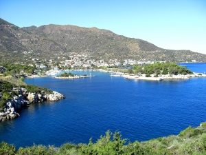
Saronic Gulf
The Saronic Gulf or Gulf of Aegina in Greece forms part of the Aegean Sea and defines the eastern side of the isthmus of Corinth. It is the eastern terminus of the Corinth Canal, which cuts across the isthmus.
The gulf includes the islands of; Aegina, Salamis, and Poros along with smaller islands of Patroklou and Fleves. The port of Piraeus, Athens' port, lies on the northeastern edge of the gulf. The site of the former Ellinikon International Airport is also in the northeast.
Beaches line much of the gulf coast from Poros to Epidaurus, Galataki to Kineta and from Megara to Eleusis and from Piraeus down to Anavyssos. Athens' urban area surrounds the northern and the eastern coasts of this gulf.
Bays in the gulf include Phaleron Bay, Elefsina Bay to the north, Kechries Bay in the northwest and Sofiko Bay in the east.
The volcano of Methana is to the southwest along with Kromyonia at the Isthmus of Corinth, Aegina and Poros. Methana is also the youngest most active volcano center and forms the northwestern end of the cycladic arch of active volcanoes that includes Milos island, Santorini island and Nisyros island. A hydropathic institute at Methana makes use of the hot sulphurous water that still surfaces in the area. The most recent eruption was of a submarine volcano north of Methana in the 17th century.
The gulf has refineries around the northern part of the gulf including east of Corinth and west of Agioi Theodoroi, Eleusis, Aspropyrgos, Skaramangas and Keratsini. These refineries produce most of Greece's refined petroleum products, a large proportion of which are then exported. Commercial shipping to the refineries, Piraeus and to and from the canal make the gulf quite a busy area with commercial shipping.
4 DAYS ROUTE 5 DAYS ROUTE
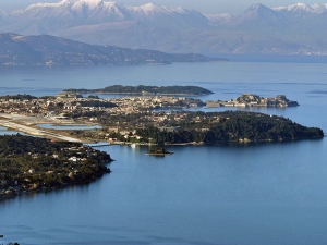
Kerkyra Island
Corfu is a Greek island in the Ionian Sea. It is the second largest of the Ionian Islands, and, including its small satellite islands, forms the edge of the northwestern frontier of Greece. The island is part of the Corfu regional unit, and is administered as a single municipality. The municipality includes the island Corfu and the smaller islands Ereikoussa, Mathraki and Othonoi. The principal city of the island and seat of the municipality (pop. 32,095) is also named Corfu. Corfu is home to the Ionian University.
The island is bound with the history of Greece from the beginning of Greek mythology. Its Greek name, Kerkyra or Korkyra, is related to two powerful water symbols: Poseidon, god of the sea, and Asopos, an important Greek mainland river. According to myth, Poseidon fell in love with the beautiful nymph Korkyra, daughter of Asopus and river nymph Metope, and abducted her.Poseidon brought Korkyra to the hitherto unnamed island and, in marital bliss, offered her name to the place: Korkyra, which gradually evolved to Kerkyra (Doric). Together, they had a child they called Phaiax, after whom the inhabitants of the island were named: Phaiakes. This term was transliterated via Latin to Phaeacians. Corfu's nickname is The island of the Phaeacians.
4 DAYS ROUTE 5 DAYS ROUTE
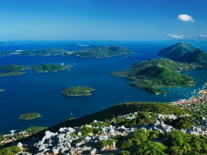
Lefkada Island
Lefkada, or Leucas or Leucadia or Lefkas or Leukas is a Greek island in the Ionian Sea on the west coast of Greece, connected to the mainland by a long causeway and floating bridge. The principal town of the island and seat of the municipality is Lefkada. It is situated on the northern part of the island, approximately 20 minutes by automobile away from Aktion National Airport. The island is part of the regional unit of Lefkada.
Lefkada measures 35 kilometres (22 miles) from north to south, and 15 kilometres (9 miles) from east to west. Its area is 336 square kilometres (130 sq mi). Its highest point is the mountain Stavrota, 1,158 metres (3,799 feet) above sea level, situated in the middle of the island. The east coast section of the island has small resorts of Lygia, Nikiana and Perigiali, all north of Nidri, the largest resort on the island. It is set in a sheltered location with views across to Skorpios—formerly owned by Aristotle Onassis, Meganissi and other small islands, as well as the Greek mainland. The main coastal road from Lefkada to Vasiliki runs through the village, although a bypass has now been completed which skirts the village to the west. There are regular car ferries to Kefalonia, Ithaca and Meganissi.
4 DAYS ROUTE 5 DAYS ROUTE